

Ahsan Iqbal Urges Global Space Tech Partnerships to Fight Climate Crisis at Islamabad Summit
Tuesday, 27 October 2026
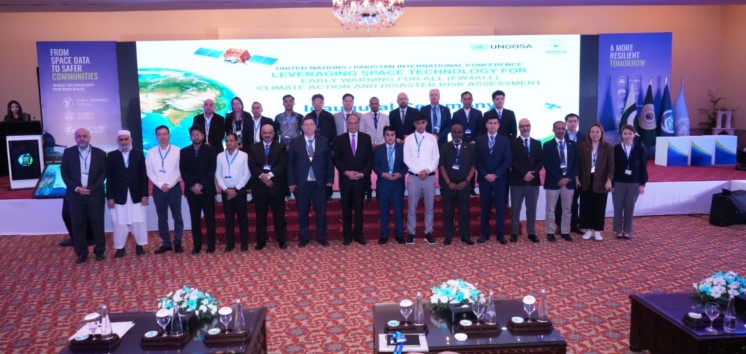
SUPARCO, UN, and International Space Agencies Convene a 5-Day Conference to Leverage Satellite Capabilities for Disaster Early Warning Systems and Economic Resilience
Syed Naveed Hussain
ISLAMABAD: Federal Minister for Planning, Development and Special Initiatives Professor Ahsan Iqbal called for integrating space-based technology and international cooperation into national economic planning to combat climate change, warning that climate risks pose severe threats to Pakistan's GDP and fiscal stability.
Speaking at the inauguration of a five-day international conference on “Leveraging Space Technology for Early Warnings for All (EW4All) organised by the Space and Upper Atmosphere Research Commission (SUPARCO) in collaboration with the United Nations Office for Outer Space Affairs (UNOOSA), the Inter-Islamic Network on Space Sciences and Technology (ISNET) and the Asia-Pacific Space Cooperation Organization (APSCO), the conference will continue from October 27 to 31, 2026, the minister highlighted the critical role of satellite observation in strengthening early warning systems and disaster risk assessment. The summit brings together around 250 policymakers and technical experts from 20 countries to develop actionable recommendations for climate action and emergency preparedness.
Referring to the devastating floods of 2022, the minister noted that the direct losses caused by the disaster were equivalent to approximately 2.2 per cent of Pakistan’s Gross Domestic Product (GDP).
Iqbal emphasised that climate resilience must be integrated into national economic planning and public-sector development projects. He said satellite-based Earth observation, meteorological monitoring and communication systems could significantly improve disaster forecasting, risk assessment, emergency response and the monitoring of environmental changes.
The minister underscored the need to translate technological advancements into tangible outcomes through effective policies, stronger institutional coordination and enhanced international cooperation. Referring to the United Nations’ Early Warnings for All initiative, he said timely and reliable warnings were essential for reducing disaster-related losses and protecting vulnerable communities.
He also called for improved data-sharing mechanisms, investment in human and institutional capacity, innovative financing arrangements and stronger regional cooperation. Urging conference participants to develop actionable recommendations on institutional coordination, data sharing, financing and capacity building, he assured them that the Ministry of Planning, Development and Special Initiatives would consider the recommendations in the national planning process.
SUPARCO Chairman Muhammad Yousaf Khan welcomed the participants and highlighted the growing importance of space-based applications in climate monitoring, disaster management and early warning systems. He said SUPARCO was developing and utilising satellite-based capabilities to support national priorities, particularly environmental monitoring, disaster risk assessment and the timely provision of information to relevant stakeholders.
The inaugural session was also attended by ISNET Executive Director Munir Ahmad Asad, UNOOSA Director Aarti Holla-Maini and APSCO Secretary-General Dr Jiang Hui. Their participation highlighted the importance of international collaboration and knowledge-sharing in harnessing space science and technology for sustainable development and disaster resilience.
The conference has attracted representatives from several international organisations, including the United Nations World Food Programme (WFP) and the International Telecommunication Union (ITU), as well as space and research agencies from partner countries.
International participants include Indonesia’s National Research and Innovation Agency (BRIN), the Iranian Space Research Center, Iraq’s Space Research and Technology Center, the Turkish Space Agency, TÜBİTAK Space Technologies Research Institute, Vietnam’s National Remote Sensing Department and Ministry of Agriculture and Environment, and Nepal’s Ministry of Energy, Water Resources and Irrigation.
Pakistan’s participation spans a broad range of government, regulatory, disaster management and research institutions, including the Ministry of Climate Change and Environmental Coordination, Ministry of Foreign Affairs, National Disaster Management Authority (NDMA), Pakistan Meteorological Department, Pakistan Climate Change Authority, National Disaster Risk Management Fund, Planning Commission, State Bank of Pakistan, Securities and Exchange Commission of Pakistan, Federal Flood Commission, Pakistan Environmental Protection Agency, Punjab Forest Department and Punjab Information Technology Board. Universities and research institutions are also participating in the conference.
The technical programme covers a wide range of subjects, including geospatial technologies for disaster risk reduction, flood risk modelling, multi-hazard mapping, glacial lake outburst flood (GLOF) early warning systems, hydrodynamic modelling, and satellite-based monitoring of glaciers, forests, agricultural land and water resources.
Experts will also discuss climate-resilient infrastructure, climate risk financing, crop-yield loss estimation, climate monitoring and the use of artificial intelligence (AI) and geospatial AI (GeoAI) to improve hazard detection, impact assessment and early warning capabilities.
The conference is expected to provide a platform for strengthening institutional partnerships, sharing technical expertise and developing practical solutions to climate-related challenges. Its deliberations aim to promote the effective use of satellite-based information in disaster preparedness, climate action and evidence-based decision-making, contributing to more resilient communities in Pakistan and beyond.

More from Pakistan News


Comments
No comments yet. Be the first to comment!
Leave a Comment